×

OpenWeather
Meteorological Service

Dan Hart Speak to the Chief
Meteorologist Dan Hart and
his team!
Building visual agro service based on weather and satellite data  I Part 1: Agro Dashboard

Building visual agro service based on weather and satellite data I Part 1: Agro Dashboard

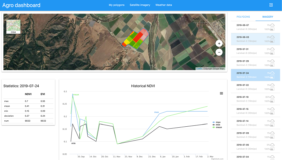
OpenWeather is delighted to offer fast and simple APIs for both weather data and satellite imagery. 

Specifically for agro-users, we have selected a set of APIs that can be incredibly useful for work in the context of...

OpenWeather 2019: results of the year. Historical weather data,  Weather API, Agro Dashboard

OpenWeather 2019: results of the year. Historical weather data, Weather API, Agro Dashboard

So, the new 2020 is nearly upon us and it is time to sum up what we have done in 2019.

Dive into Agro API | Part 4 – Satellite Imagery

Dive into Agro API | Part 4 – Satellite Imagery

The Satellite Imagery API is a part of our Agriculture API (Agro API) for the agricultural sector. OpenWeather<...

Building visual agro service based on weather and satellite data |  Part 2: Satellite imagery

Building visual agro service based on weather and satellite data | Part 2: Satellite imagery

This article is describing the ‘Satellite imagery’ page

Discover NDVI and its practical uses in agriculture

Discover NDVI and its practical uses in agriculture

Quite often we receive questions like what NDVI is, how to use it and why would a farmer require using it at all.

Dive into Agro API Part 5 | Accumulated temperature and precipitation by polygon

Dive into Agro API Part 5 | Accumulated temperature and precipitation by polygon

The API to provide accumulated temperature and precipitation is part of the functionality of our APIs for the agricultural sector. Accumulated temperature and precipitation are calculated based on historical weather data, and play a fundament...

Introducing the OpenWeather History API Full Archive

Introducing the OpenWeather History API Full Archive

Introducing the OpenWeather History API Full Archive - up to 40 years of detailed weather data for any specified global location.

The fruity future of wine

The fruity future of wine

The fruity future of wine.

Visual global agricultural data in less time than a raindrop takes to fall to earth.

Visual global agricultural data in less time than a raindrop takes to fall to earth.

Visual global agricultural data in less time than a raindrop takes to fall to earth.

You know where you are with the OpenWeather Geocoding API.

You know where you are with the OpenWeather Geocoding API.

Our API takes the name of any global location or zip code, and converts it into a list of coordinates (known as direct geocoding) as well as converting a geolocation into a list of place names (reverse geocoding).

We use cookies to personalize content and to analyze our traffic. Please decide if you are willing to accept cookies from our website.