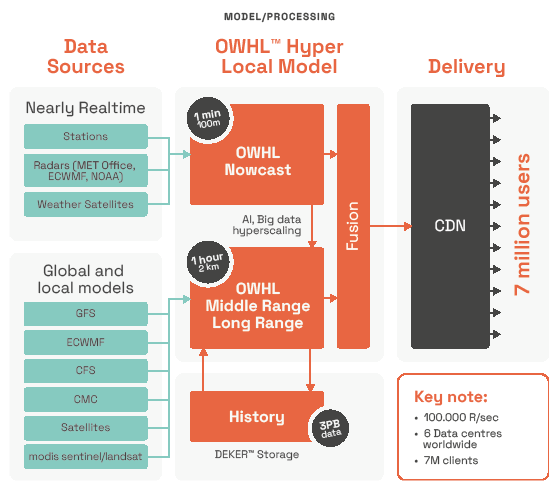
OWHL™ OpenWeather Hyper-Local Forecasting Model Overview
OWHL ™ OpenWeather Hyper-Local Forecasting Model enables the delivery of weather data with high resolution and exceptional speed, ensuring timely and precise forecasts. It is an advanced system delivering precise, hyper-local weather forecasts that meet critical business requirements. It assimilates data from weather stations, radar, satellite imagery, global forecasting models, into sophisticated numerical weather prediction models. Machine learning refines these inputs detecting anomalies, incorporating new observations, and producing forecasts for local microclimates. Updated roughly every 10 minutes, OWHL ™ ensures accurate, timely insights essential for diverse commercial applications.
OpenWeather Hyper Local Forecasting System
The OpenWeather modelling system blends global model outputs with radar, satellite, and thousands of station/IoT observations. By using machine learning it corrects biases and produce a single, unified forecast with frequent (every 10 minutes) updates. It offers “NIR” (Nowcasting Immediate Range) for the next 3 hours and extends out to weekly and monthly horizons by incorporating global and climate models.OpenWeather's forecasting system comprises two major modules, OWHL™ NIR Nowcast Short-Range Forecast and OWHL™ Middle-Range and Long-Range Forecast.
OWHL™ NIR Nowcast Short-Range Forecast
The OWHL NIR (Nearly Real-Time) forecasting system uses an extensive range of global data sources, each contributing to accuracy, resolution, and timeliness.
- Weather stations provide highly precise measurements with an accuracy of ±0.1°C for temperature, ±0.5 m/s for wind speed, and ±2% for humidity. They operate at a fine resolution of approximately 10 meters and offer near-instantaneous updates with latency measured in fractions of a second.
- Radar systems (from the Met Office, ECMWF, NOAA) provide detailed precipitation data with an accuracy of ±1 dBZ, and can distinguish between rain and snow with about 85-90% accuracy. Resolution ranges from 250 meters to 1 kilometer, with a latency of a few minutes.
- Meteorological satellites capture large-scale atmospheric patterns. Temperature retrievals have an uncertainty of ±0.5°C, and cloud detection accuracy is around 90%. Resolution varies from 1 kilometer (visible) to 5 kilometers (infrared and microwave), with latency up to 10 minutes.
By integrating data from these sources, OpenWeather achieves a balance between local precision and large-scale atmospheric analysis, leading to more accurate and timely weather predictions. This data undergoes rigorous quality control and integration processes, producing a refined global forecast at a resolution of approximately 100 m. Short-term forecasts are updated every 1 minute, offering accurate weather predictions for up to 3 hours ahead.
OWHL™ Middle-Range and Long-Range Forecast
For medium and longer-term forecasts, OpenWeather utilizes deterministic outputs from respected global numerical weather prediction models. The OWML™ ML module aggregates and normalizes data from these sources, employing advanced AI technologies to manage data gaps and enhance forecasting resolution up to 1 km, with forecast horizons extending up to 1.5 years. Forecasts are recalculated every 1 hour, with data continually archived for historical analyses and future model enhancements.
- OWHL™ NIR (OpenWeather Nowcast Model) provides immediate short-term forecasts for 0–3 hours ahead. It achieves high-resolution forecasting with resolutions ranging from 100 meters to 1 kilometer. Utilizing real-time radar, satellite imagery, and sensor data, this model updates every minute. The OWHL ™ NIR employs AI-enhanced precipitation tracking, delivering precise predictions, particularly effective in urban and densely populated regions worldwide.
- NOAA GFS (Global Forecast System) is designed for medium-range forecasting, offering predictions up to 16 days in advance. Initially, it provides a high resolution of 13 kilometers, tapering to 34 kilometers after the first 10 days. The GFS model updates four times daily, covering global atmospheric conditions comprehensively. It is widely recognized for its open-access data, which supports broad-scale weather analysis and predictions globally.
- ECMWF IFS (Integrated Forecasting System) excels in medium-range forecasting, known for its superior accuracy and sophisticated 4D-Var data assimilation techniques. It operates at approximately 9 kilometers resolution for deterministic forecasts and about 18 kilometers for ensemble forecasts, updating twice daily. Its industry-leading probabilistic ensemble forecasts and storm tracking capabilities make it an essential tool for weather prediction at a global scale, particularly for Europe and the North Atlantic region.
- GEM (CMC, Canadian Meteorological Centre) specializes in medium-range forecasts tailored to North America, providing resolutions of approximately 25 kilometers. Integrated into the North American Ensemble Forecast System (NAEFS), the GEM model effectively captures North American geography, complex terrains, and high-latitude weather patterns. It is updated twice daily.
- NOAA CFS (Climate Forecast System) focuses on extended-range forecasting, providing seasonal climate anomaly predictions with resolutions around 56 kilometers. Updated daily, it employs ensemble methods for long-range outlooks, utilizing coupled ocean-atmosphere modeling. It effectively predicts seasonal temperature and precipitation trends on a global scale.
- WRF Models provide high-resolution regional forecasts, typically between 1 to 3 kilometers resolution. These models are highly detailed and customizable, regularly updated hourly or as required. They are ideal for forecasting localized weather events, including thunderstorms, urban microclimates, and severe weather conditions, tailored to specific regional needs.
Historical Weather with Data Storage DEKER™
OpenWeather DEKER™ database stores over 3 PBof historical weather data produced by the OWHL™ Middle-Range and Long-Range Forecast component. DEKER™ is a Python-based platform developed by OpenWeather, designed to efficiently store and access extensive weather data. It supports scalable storage of large virtual arrays through tiling, enabling efficient management of substantial datasets.
DEKER™ facilitates parallel processing of these array tiles and incorporates its own locking mechanism to allow concurrent read and write operations, enhancing data handling efficiency. The platform also offers flexible data slicing using timestamps and named labels, and supports industry-standard formats like NumPy and Xarray, simplifying integration into existing workflows. Additionally, DEKER™ provides storage-level data compression and chunking via HDF5, optimizing storage efficiency.